

Development of a tropical storm possible in the first week of September
The first tropical storm in the Atlantic since mid-August could form before the end of the first week of September.
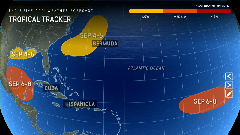
The National Hurricane Center is currently tracking three tropical waves in the Atlantic Ocean, the agency said Wednesday morning.
The first wave is currently moving westward at about 32 km/h, the NHC said, causing “a large area of scattered showers and thunderstorms” over Hispaniola and parts of the central Caribbean.
The NHC says “some development” is possible late this week as the wave slows over the northwestern Caribbean Sea, or early next week over the southwestern Gulf of Mexico. The hurricane center says there is a 30 percent chance the wave will develop in the next seven days.
The second wave is located about 900 miles east of the Lesser Antilles. According to the NHC, this system is expected to develop slowly over the next few days as it moves west-northwestward.
According to the NHC, environmental conditions are expected to be “unfavorable” for further development through the end of the week, and there is a 10 percent chance that the wave will develop in the next seven days.
The third and final wave is located in the far eastern Atlantic and is expected to develop slowly as it moves slowly northwestward across the eastern tropical Atlantic, the NHC said. This system could produce locally heavy rains in parts of Cape Verde on Thursday and has a 30 percent chance of developing in the next seven days, according to the hurricane center.
Relentless heat: Phoenix reaches 38 degrees for the 100th day in a row
Storm tracker for the Atlantic
Is September a busy month due to Atlantic hurricane season?
Meteorologists predict Atlantic activity will continue to increase in September. Dry, dusty air from Africa that prevents storms from forming in the Atlantic is expected to subside, AccuWeather hurricane expert Alex DaSilva told USA TODAY last week.
“The dust will disappear and allow the Atlantic to wake up,” he said.
He added that water temperatures in many parts of the ocean are high enough to allow storms to form and spread.
DaSilva said water temperatures in the Gulf of Mexico are at record levels. “If something develops in the Gulf, it could move very quickly. People need to be careful: Storms can develop quickly and intensify quickly.”
Computer models also show more activity in the Atlantic for September, as USA TODAY previously reported: “Long-range models are increasingly confident that a system worth tracking will soon form in the deep tropics of the Atlantic, and there are many reasons to believe we are in for a busy September and/or October,” wrote meteorologists Jeff Masters and Bob Henson on their blog Yale Climate Connections.
There have been more storms in the Pacific than in the Atlantic so far this year, and that’s a bit of a surprise, according to meteorologists. The Atlantic has also been eerily quiet over the past week, even though we’re approaching what is traditionally the busiest time of the season.
Gabe Hauari is a national trending news reporter for USA TODAY. You can follow him on X. @GabeHauari or email him at [email protected].
