

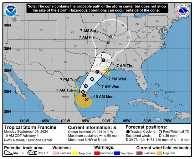
Tropical Storm Francine On Monday, Francine crept northwestward across the Gulf of Mexico on a path that forecasters expected to make landfall somewhere along the Louisiana coast later in the week. Francine is forecast to continue moving slowly before picking up speed on Tuesday while intensifying and possibly becoming a hurricane before it is expected to make landfall on Wednesday.
Maps released by the National Hurricane Center illustrated Francine’s forecast as the storm gained strength and became better organized Monday afternoon.
NOAA/National Hurricane Center
“Francine is forecast to become a hurricane when it makes landfall along the northwest Gulf Coast on Wednesday or Wednesday night, and there is an increasing likelihood of life-threatening flooding from storm surge in portions of coastal Upper Texas and Louisiana where a Storm Surge Warning is in effect,” meteorologists said Monday in a warning from the National Hurricane Center, which also pointed to “an increasing risk of damaging hurricane-force winds in portions of southern Louisiana” beginning Wednesday.
At 2 p.m. EDT, the center was located about 180 miles south-southeast of the mouth of the Rio Grande and about 450 miles south-southwest of Cameron, Louisiana, not far from the eastern border with Texas. Francine was moving north-northwest at 5 mph at the time, unchanged from an earlier measurement earlier in the morning.
NOAA/National Hurricane Center
Maximum sustained winds were 60 mph – a significant jump from the 50 mph reported by the hurricane center three hours earlier, although this is still well below the threshold to be considered a hurricane. The maximum sustained winds of a tropical storm must reach 74 mph to meet the criteria for Category 1 on the Saffir-Simpson Hurricane Wind Scale.
Storm surge, hurricane, and tropical storm warnings were issued for various coastal areas of Louisiana and Texas when meteorologists upgraded Francine from its original tropical depression designation to a full-fledged storm at 11 a.m., and those warnings remained in effect into the afternoon. Areas from High Island, Texas, eastward to the Mississippi-Alabama border were under storm surge warnings, including Vermilion Bay, Lake Maurepas, and Lake Pontchartrain. A tropical storm warning was active for areas east of High Island to Cameron and east of Grand Isle, Louisiana, to the mouth of the Pearl River, which included Lake Pontchartrain and Lake Maurepas, and a hurricane warning was in effect from Cameron eastward to Grand Isle.
NOAA/National Hurricane Center
A storm surge warning means that there is a possibility of life-threatening flooding in the danger area within 48 hours. Hurricane and tropical storm Warnings mean that the conditions typically associated with those weather events are possible within the same time period. Warnings are different from advisories issued by the hurricane center for areas where the arrival of storm surge, hurricanes, or tropical storms is imminent.
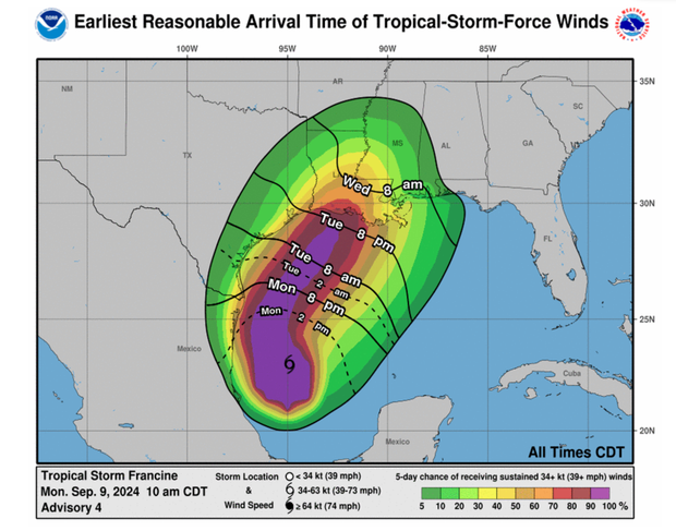
According to the hurricane center, tropical storm-force winds extended as far as 160 miles (257 kilometers) from Francine’s center Monday afternoon. After moving slowly throughout the day, the forecaster said the storm would accelerate toward the northeast on Tuesday, raging just off the coast of the northern Gulf of Mexico. On Wednesday, they expected Francine to approach the coast of Louisiana and Upper Texas after a significant period of intensification overnight and into the morning.
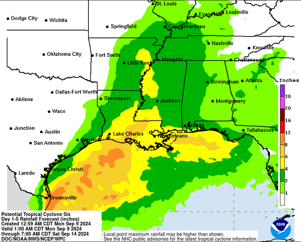
Francine was expected to dump 4 to 8 inches of rain in coastal areas from northeastern Mexico to the southern and upper coasts of Texas, as well as southern Louisiana and southern Mississippi, by Thursday morning, but certain parts could accumulate up to 12 inches of rain. Meteorologists warned that this would pose a risk of “significant” flash flooding and urban flooding. They noted that a dangerous storm surge associated with Francine could amplify the flooding and inundate coastal areas.
NOAA/National Hurricane Center
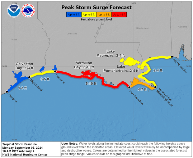
If storm surge and high tide occur simultaneously, water levels could rise 5 to 10 feet above ground level from Cameron to Port Fourchon, Louisiana, and around Vermilion Bay, the hurricane center said. From Port Fourchon to the mouth of the Mississippi, water levels could reach 4 to 7 feet, and from Cameron to High Island, 3 to 5 feet.
According to meteorologists, Francine appeared to move slightly eastward between Monday morning and early afternoon, suggesting the storm would make landfall in Louisiana sometime Wednesday evening. This was a slight deviation from previous trajectories that suggested Francine would make landfall in either Louisiana or eastern Texas.
“The estimated movement is still difficult as the center has only recently formed,” they said in a statement at 11 a.m., acknowledging that some elements of Francine’s course remain uncertain.
