

At the end of August, tropical development in the Atlantic becomes more likely
There was a tropical calm in the Atlantic during the last weeks of August, but tropical storms could return as early as the first week of September.
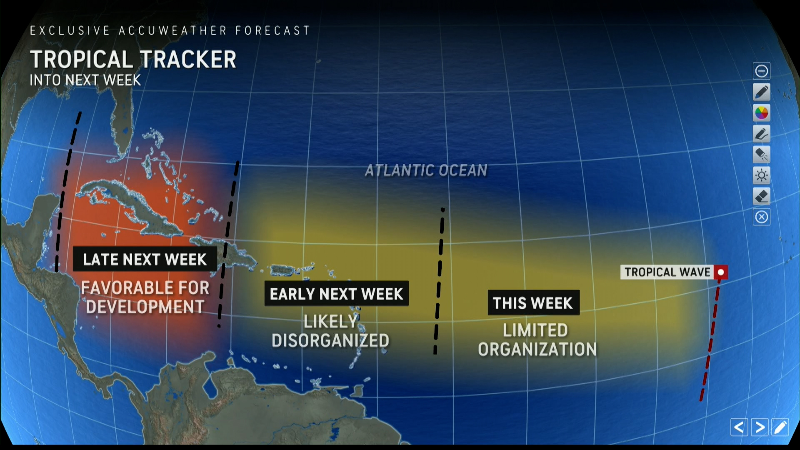
The National Hurricane Center is tracking three tropical waves in the Atlantic that could develop into tropical depressions later this week.
The NHC issued an alert early Tuesday morning that “intermittent showers and thunderstorms” remained associated with a tropical wave currently over Hispaniola and the central Caribbean.
The westward-moving wave could encounter favorable conditions for further development when it reaches the western Caribbean and southwestern Gulf of Mexico later this week and over the weekend, the NHC said. At that time, a tropical depression could form.
Elsewhere, another tropical wave is also currently producing showers and thunderstorms in the far eastern Atlantic. The NHC says environmental conditions are expected to become “somewhat more conducive to development” and a tropical depression may form in a few days “as the disturbance slowly moves west-northwestward across the eastern tropical Atlantic.”
The third system is currently halfway between the west coast of Africa and the Lesser Antilles and is also bringing intermittent showers and thunderstorms, according to the NHC. The agency says some “slow development” is possible over the next few days as the system moves west-northwestward, but that environmental conditions are expected to become “unfavorable” for further development by the end of the week.
The probability that the first two tropical waves will develop within the next seven days is 40 percent, and the probability of the third is 10 percent, the NHC said.
Storm tracker for the Atlantic
Is September a busy month due to Atlantic hurricane season?
Meteorologists predict Atlantic activity will continue to increase in September. Dry, dusty air from Africa that prevents storms from forming in the Atlantic is expected to subside, AccuWeather hurricane expert Alex DaSilva told USA TODAY last Wednesday.
“The dust will disappear and allow the Atlantic to wake up,” he said.
He added that water temperatures in many parts of the ocean are high enough to allow storms to form and spread.
DaSilva said water temperatures in the Gulf of Mexico are at record levels. “If something develops in the Gulf, it could move very quickly. People need to be careful: Storms can develop quickly and intensify quickly.”
Computer models also show more activity in the Atlantic for September, as USA TODAY previously reported: “Long-range models are increasingly confident that a system worth tracking will soon form in the deep tropics of the Atlantic, and there are many reasons to believe we are in for a busy September and/or October,” wrote meteorologists Jeff Masters and Bob Henson on their blog Yale Climate Connections.
There have been more storms in the Pacific than in the Atlantic so far this year, and that’s a bit of a surprise, according to meteorologists. The Atlantic has also been eerily quiet over the past week, even though we’re approaching what is traditionally the busiest time of the season.
Gabe Hauari is a national trending news reporter for USA TODAY. You can follow him on X. @GabeHauari or email him at [email protected].
