

Development of a tropical storm possible in the first week of September
The first tropical storm in the Atlantic since mid-August could form before the end of the first week of September.
The National Hurricane Center is currently monitoring five tropical disturbances in the Atlantic Ocean, the agency said in an alert early Thursday morning.
There has been a surprising lull in hurricane activity in the Atlantic in recent weeks. In fact, there have been no named storms in the Atlantic since Ernesto on August 12, according to Phil Klotzbach, a hurricane forecaster at Colorado State University. He said the only time since 1966 has there been no named storms in the Atlantic was between August 13 and September 3. The other year was 1968, when only 8 named storms formed in total.
“This exceptionally quiet period is particularly notable as it coincides with the time of year when the Atlantic is climatologically very busy,” Klotzbach wrote in an online weather forecast update published on September 3.
Relentless heat: Phoenix reaches 38 degrees for the 100th day in a row
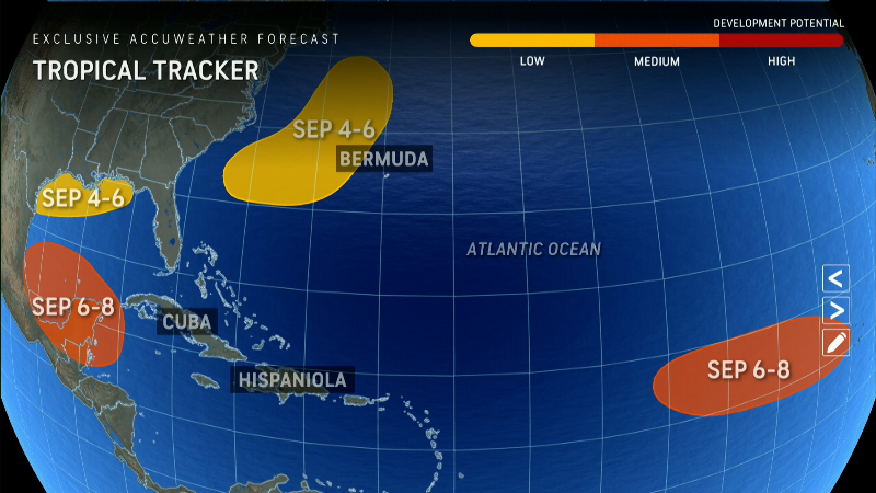
NHC tracks 4 tropical waves in the Atlantic
The first system is currently causing widespread rain showers and thunderstorms in the northwestern Gulf of Mexico, including near the coast of Louisiana and Texas, the NHC said Thursday morning.
The hurricane center said upper-level winds will be “less conducive to development” through Friday and Saturday as a frontal boundary approaches the system. Although development is unlikely, heavy rains are expected in parts of the northern Gulf Coast over the next few days, the NHC said.
The National Weather Service in New Orleans said a flood warning was in effect for parts of southeast Louisiana and the Mississippi Gulf Coast until Friday evening. Between 7.5 and 12.5 centimeters of rain were possible by Saturday, but locally higher amounts “cannot be ruled out.”
The second wave is currently described by the NHC as a “non-tropical low pressure area” and is located a few hundred miles east of North Carolina.
The system is producing “limited showers and thunderstorm activity” and could assume “subtropical characteristics” over the next few days as it moves north-northeastward and remains off the coast of the northeast coast of the United States, the NHC said.
“Once the low pressure system moves over cooler waters by Saturday evening, no further subtropical development is expected,” the NHC said in its warning. The probability of its formation in the next seven days is 20 percent.
The third wave is currently producing showers and thunderstorms over the eastern tropical Atlantic, and slow development is possible over the next few days as it moves northwest or north, the NHC said. There is a 20 percent chance that this wave will develop over the next seven days.
The fourth wave is currently moving rapidly westward across the western Caribbean at about 32 km/h and continues to cause a “wide area of disorganized showers and thunderstorms,” the NHC said.
Some development is possible in a few days after the system crosses the Yucatan Peninsula in Mexico and moves over the southwestern Gulf of Mexico. The NHC gives this wave a 30 percent chance of forming in the next seven days.
The fifth and final wave is currently located several hundred miles east of the Lesser Antilles. Strong winds will limit the development of this system on its west-northwest side over the next few days, the NHC said.
However, early next week, environmental conditions may become more favorable for slow development as the system moves northwestward across the southwestern Atlantic. The NHC gives this system a 10 percent chance of formation in the next seven days.
Storm tracker for the Atlantic
Where are the hurricanes?
Despite widespread warm waters throughout the basin, too much dry air, dust from the Sahara and disruptive winds have hampered tropical development, AccuWeather said. “We’re also monitoring a large pocket of cold water off the west coast of Africa,” AccuWeather hurricane expert Alex DaSilva said, adding that it’s disrupting the showers and thunderstorms that normally develop into tropical storms and hurricanes.
So far this year there have been more storms in the Pacific than in the Atlantic, and that’s a bit of a surprise, according to meteorologists.
Some weather services, including AccuWeather, are revising their predictions of an exceptionally active hurricane season. AccuWeather had predicted that up to 25 storms would form, but has lowered that number to 16-20, which is still above the average of 14.
For the immediate future, Klotzbach’s team predicts below-average activity over the next few weeks as large-scale weather factors continue to help reduce storm activity.
The Atlantic hurricane season lasts until November 30th.
Gabe Hauari is a national trending news reporter for USA TODAY. You can follow him on X. @GabeHauari or email him at [email protected].
