

Development of a tropical storm possible in the first week of September
The first tropical storm in the Atlantic since mid-August could form before the end of the first week of September.
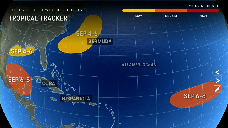
The National Hurricane Center is currently monitoring four tropical disturbances in the Atlantic, including one in the Gulf of Mexico that is expected to bring heavy rains to parts of the Gulf Coast, the agency said in an alert Friday morning.
There has been a surprising lull in hurricane activity in the Atlantic in recent weeks, and the numerous disturbances but no active storms remain unusual.
No named storms have formed since August 12. There hasn’t been such a long stretch between August and September without hurricane formation since 1968, says Phil Klotzbach, chief hurricane researcher at Colorado State University, where Bill Gray pioneered seasonal hurricane forecasting 40 years ago.
This lull in activity has surprised and confused the scientists who make seasonal forecasts, despite predictions of a hyperactive season. Most forecasters expected up to 25 named storms. So far, however, only five have formed, including three hurricanes.
Where are hurricanes predicted? Experts fear that they are yet to come
Four tropical turbulences are brewing in the Atlantic
The first system tracked by the NHC, designated Invest 90L, is expected to bring heavy rains to parts of the Gulf Coast this weekend.
Rain and thunderstorm activity associated with the system had subsided Thursday evening, the NHC said, adding that winds are expected to remain “unfavorable for significant development of this system” as it moves across the northwestern Gulf of Mexico.
The National Weather Service in New Orleans has extended its flood warning through Saturday morning for parts of southeast Louisiana and the Mississippi Gulf Coast. Two to four inches of rain are possible, with locally higher amounts “not impossible.” The NWS says the greatest danger is in urban areas south of I-10/I-12, including New Orleans, Gulfport and Biloxi.
The second system, designated Invest L99, is currently located several hundred miles east of the U.S. Mid-Atlantic coast. The NHC said the system is “increasingly adopting a non-tropical structure” and its chance of developing “subtropical characteristics” appears to be decreasing.
The system’s low pressure system is expected to move over cooler waters late Friday or early Saturday, and no further development is expected after that, the NHC said. Meteorologists give the system a 30 percent chance of developing in the next seven days.
The third tropical disturbance is currently producing “disorganized showers and thunderstorms” near the coast of Belize and the Yucatan Peninsula in Mexico. The NHC said the system is expected to move across Central America and southeastern Mexico on Friday, with slow development possible over the weekend when the system emerges over the southwestern Gulf of Mexico.
The fourth and final disturbance currently being tracked by the NHC is a “long-term low pressure system” over the eastern tropical Atlantic Ocean that is producing “minimal rain and thunderstorm activity.”
The NHC said any development, if any, is likely to be “slow-moving” during the first half of next week as the disturbance moves northwest or northward across the eastern tropical Atlantic.
Storm tracker for the Atlantic
Hurricane activity could increase
Although 2024 is becoming less likely to be a record year, experts still expect the season to be busier than usual. The season usually peaks around September 10, but there are still 12 weeks until it ends on December 1.
“From our current perspective, everything is still going according to plan,” Dan Harnos, a meteorologist on the Climate Prediction Center team that produces the National Oceanic and Atmospheric Administration’s seasonal outlook, told USA TODAY on Thursday.
Conditions are still favorable, with very warm and record-high sea temperatures across much of the Atlantic, Harnos said. “With all that warm water out there, there’s a lot of room for a tide turn. Things could change quickly.”
“I don’t think anyone expected a lull like this at the end of August,” Harnos said. “But we’ve had a decent amount of activity and I think it will pick up again at some point. It’s just a question of what the numbers will look like at the end.”
Dinah Voyles Pulver covers climate change and the environment for USA TODAY. She has covered hurricanes, tornadoes and severe weather for more than 30 years. Reach her at [email protected] or @dinahvp.
Gabe Hauari is a national trending news reporter for USA TODAY. You can follow him on X. @GabeHauari or email him at [email protected].
