From Chris Dolce, Caitlin Kaiser, Jonathan Belles
2 hours ago


- The National Hurricane Center is monitoring three areas with possible tropical development.
- One of them is currently in the Caribbean and could develop near Yucatan or in the southwestern Gulf of Mexico.
- Two other disturbances are located in the central and eastern Atlantic.
Tropical development is possible in three areas monitored by the National Hurricane Center (NHC), one in the Caribbean and two systems in the central and eastern Atlantic.
It’s been two weeks since the last time a named storm (Hurricane Ernesto) passed through the Atlantic basin. Here’s the latest information on when the next Atlantic storm, to be named Francine, might form.
Development potential in the Caribbean and the Gulf: This system is an area of unsettled weather, referred to as a tropical wave, located in the central Caribbean. It is currently producing disorganized showers and thunderstorms as it moves westward.
Tropical development is possible in the northwestern Caribbean Sea late this week before it reaches Belize or Mexico’s Yucatan Peninsula, or this weekend when this system emerges in the southwestern Gulf of Mexico. At that point, atmospheric conditions could become more favorable for the formation of a tropical depression or storm.
An obstacle to the development of this system so far is the stable air, which limits its ability to generate and organize persistent thunderstorms.
In the short to medium term, regardless of development, this system could bring heavy rains and gusty winds to parts of Jamaica, Central America, and Mexico. It is still unclear what threat, if any, this system could pose to the continental United States.


Attention is also being paid to developments in the central and eastern Atlantic systems: One of the Atlantic disturbances promising development is located just off the coast of Africa near the Cape Verde Islands. This system has a medium probability of development as it moves west-northwest through the Atlantic this week.
In Cape Verde, this system could cause rain and gusty winds over the next one to two days.
A second system is swirling in the central Atlantic. Slow development is possible before conditions become less favorable later this week. It poses no threat to land areas.
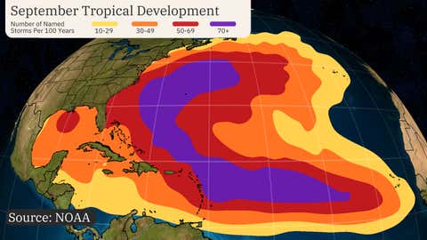
Typical for this season: The two areas of possible tropical development are in areas that typically experience activity at this time of year. September is the month with the most hurricanes in the Atlantic, so it is the month with the greatest potential for development during the six-month hurricane season.


